| Between February 2009 and December 2010, we spoke to hundreds of people about the future. A few dozen of these people were nice enough to make predictions about the future. Some of these predictions took the form of elaborate short stories, or intricate drawings or maps. Click on their names to see what these participants submitted to the project. (Note: to see these predictions in context, click on "Timeline & findings", above.)
|
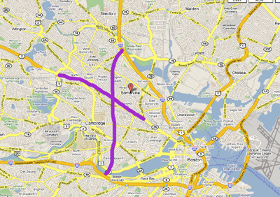
2x in 2022, 93x in 2029. Due to increasing population growth and deteriorating public transportation (due to continued mismanagement and failing government subsidies as MA keeps hitting budget shortfalls, even the proposed gas tax doesn't help much as cars are quickly switching to be ultra-efficient and/or alternative fuel based [including the new bicycle hybrid single-person cars which harness foot energy along with solar charged batteries and night-time micro-windturbines for electric-assisted propulsion]), traffic congestion in Somerville has grown to the point where government is forced to intervene. As there is no remaining landmass for additional roads, the only solution is to build secondary roads above existing roads. Since much of the congestion in Somerville is getting through the town, the obvious solution was to build in additional highways which can also serve outlaying properties. Thus the new Route 2X extension (which also has the effect of mitigating traffic problems at the Arlington/Cambridge border where Rte 2 splits off) - Rte.2x begins with a ramp preceding the traffic light at the end of the highway portion of Rte.2 and continues across Somerville and merges with Rte 28 just at the bridge over Union Sq. This new highway will have no less than 2-3 exit/entrance ramps in Somerville for those foolish enough to travel/live in that traffic hell. Additionally, 93X extension travels due south across Somerville and Cambridge to connect with Memorial Drive, Storrow Drive and end with a merge onto I-90. There will be a new bridge built especially for this purpose (crossing the Charles) as existing bridges cannot handle additional traffic) Map attached with rough outline of new highways. Additionally, due to the new strategy of multiple-layer roads, all "print" map technology will become holographic to the extent that road layers can be viewed (and computerized maps will feature rotate functions as needed). (source: LuQ)
|
 (image
source: LuQ)